
Trail Maps
These maps are intended for general reference only. All maps are in PDF format and can be printed on 8.5 x 11 paper. To download the latest version of Adobe Reader, click here.
These maps include both established clearly marked trails and newer less improved trails. Do not assume all trails will be fully improved and well marked.
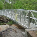
 Grills Sanctuary Self-Guided Hike Map Grills Sanctuary is located at the southern point of Hopkinton along the Pawcatuck River. It is home to multiple trails, kayak and canoe launches into the Tomaquag Brook, and picnic areas. The resently opened Polly Coon Bridge crosses the Pawcatuck River providing access the Westerly Land Trust trails which are also displayed on this map.
Click the links below to download:
Visit ExploreRI.org for more information.
 Kenyon Crossroads Self-Guided Hike Map
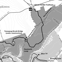
Kenyon Crossroads features upland woods, swamp and agricultural lands, an 18th century settlement and Native American stone works. Much of Tomaquag Trail is along an historic town Driftway which intersects the colonial era King’s Highway at the Four Corners. Here there are house and barn foundations and large planted sugar maples and sycamores. Numerous farm stone walls compliment the older Native American stone cairns. A boardwalk crosses a swamp, often flooded by beaver activity on Tomaquag Brook.
Click the links below to download:
- Kenyon Crossroads – Color (broad)
- Kenyon Crossroads – Color (fine)
- Kenyon Crossroads – Black and White (broad)
- Kenyon Crossroads – Black and White (fine)
Visit ExploreRI.org for more information.
 Pelloni Preserve Self-Guided Hike Map
Two wooded, hilly tracts comprise the Pelloni Preserve. The northern tract is owned by the Hopkinton Land Trust and its eastern spur reaches to the Tomaquag Brook adjacent to the site of Hopkinton’s first village. A 25 foot granite cliff complete with small caves, separates a perched wetlands from the upland forest. A man-made drainage channel at the bottom of the cliff is spanned by a traditional stone slab bridge. The second tract consists of a trail easement; part of the greater Tomaquag Trail north-south system and combined; the tracts add 1.1 miles to Tomaquag Trail. Note: As of Fall 2013, trails are rudimentary. Trails are flagged but final improvements such as widening, signs, and permanent blazing are not yet completed.
Click the links below to download:
- Pelloni Preserve – Color (broad)
- Pelloni Preserve – Color (fine)
- Pelloni Preserve – Black and White (broad)
- Pelloni Preserve – Black and White (fine)
Visit ExploreRI.org for more information.
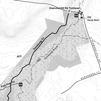 Diamond Hill Swamp Self-Guided Hike Map
This property is located along the Hopkinton Land Trust north-south Tomaquag Valley Greenway. Hikers currently connect to the Grills Wildlife Sanctuary to the south and Pelloni Preserve to the north via the road system. The Tomaquag Brook wooded flood plain is the dominant property feature with mixed hardwood uplands along Tomaquag Trail.
This is a rudimentary blazed trail without final clearing, signs or all-season stream crossings. Tomaquag Brook from Old Swim Hole south to the Pawcatuck River was canoed and fished when the entire area was cleared and farmed. The brook was well known as an excellent native trout fishery. The adjacent campground is collaborating with HLT to develop and maintain the trail system for public use. Please respect the boundary with this private campground. Note: As of Fall 2013, trails are rudimentary. Trails are flagged but final improvements such as widening, signs, and permanent blazing are not yet completed.
Click the links below to download:
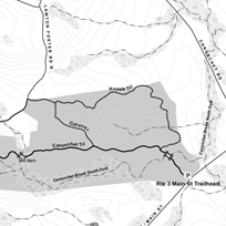 Hoxsie Preserve at Conochet Preserves Self-Guided Hike Map
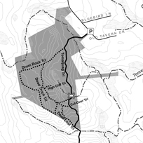
The Rte 3 Main St Trailhead serves both Hopkinton Land Trust and TNC Canonchet Preserves properties. Most trails are in the upland woods with good winter views to the wooded swamp that follows Canonchet Brook South Fork. A dam and mill operated where Canonchet Trail crosses the South Fork via a stone bridge in the west. This western area is rugged with boulder upon boulder, glacial erratics and edge outcrops.
Walking past the stone walls, house and barn foundations, the old mill and extensive stone works at every turn along CanonchetTrail links you back centuries to those who came before. Canonchet Trail continues west and north to Stubtown Road, crossing other HLT and TNC Canonchet Preserves properties.
Click the links below to download: