Hopkinton Outdoors
-
 Green Space Grant
The Hopkinton Outdoors webpage has been created by the Hopkinton Conservation Commission to provide a central repository for residents and visitors to obtain information, regarding the plentiful outdoor activities available in Hopkinton. On this webpage, you will find maps depicting the various public lands and water trails; information on boat landings, fishing, and hunting; and the location of farms that sell products directly to the general public.
Collectively, the Hopkinton Land Trust, Rhode Island Department of Environmental Management, Rhode Island Audubon Society, The Nature Conservancy and the Boy Scouts of America maintain thousands of naturally landscaped acres open for public enjoyment in Hopkinton. Residents and visitors are encouraged to enjoy the acreage, but asked to please respect the rules and regulations specific to each protected landscape.
 These maps are intended for general reference only. All maps are in PDF format and can be printed on 8.5 x 11 paper.
These maps include both established clearly marked trails and newer less improved trails. Do not assume all trails will be fully improved and well marked.
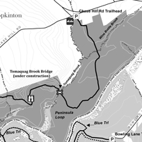
Grills Sanctuary Self-Guided Hike Map Grills Sanctuary is located at the southern point of Hopkinton along the Pawcatuck River. It is home to multiple trails, kayak and canoe launches into the Tomaquag Brook, and picnic areas. The Polly Coon Bridge crosses the Pawcatuck River providing access the Westerly Land Trust trails which are also displayed on this map.
Click the links below to download:
Grills Sanctuary – Black and White
Kenyon Crossroads Self-Guided Hike Map
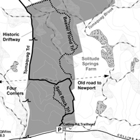
Kenyon Crossroads features upland woods, swamp and agricultural lands, an 18th century settlement and Native American stone works. Much of Tomaquag Trail is along an historic town Driftway which intersects the colonial era King’s Highway at the Four Corners. Here there are house and barn foundations and large planted sugar maples and sycamores. Numerous farm stone walls compliment the older Native American stone cairns. There is a boardwalk crossing a swamp – this area is flooded by beaver activity and will be under construction for 2023 & 2024.
Click the links below to download:
Kenyon Crossroads – Color (broad)
Kenyon Crossroads – Color (fine)
Kenyon Crossroads – Black and White (broad)
Kenyon Crossroads – Black and White (fine)
Pelloni Preserve Self-Guided Hike Map
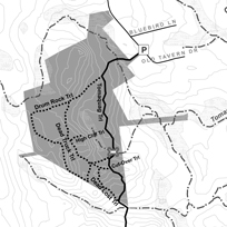
Two wooded, hilly tracts comprise the Pelloni Preserve. The northern tract is owned by the Hopkinton Land Trust and its eastern spur reaches to the Tomaquag Brook adjacent to the site of Hopkinton’s first village. A 25 foot granite cliff complete with small caves, separates a perched wetlands from the upland forest. A man-made drainage channel at the bottom of the cliff is spanned by a traditional stone slab bridge. The second tract consists of a trail easement; part of the greater Tomaquag Trail north-south system and combined; the tracts add 1.1 miles to Tomaquag Trail. Note: As of Fall 2013, trails are rudimentary. Trails are flagged but final improvements such as widening, signs, and permanent blazing are not yet completed.
- Open Sunrise to Sunset
- Observe posted rules & regulations
- Off road vehicles are prohibited
- Be aware of other trail users
- Leave no trace, please carry out trash
- During hunting season wear blaze orange
- Tomaquag Trail 1.1 mi. (white)
- Drum Rock Trail 0.4 mi (Red)
- Woods Road 0.3 mi (blue)
- Ridge Trail 0.2 mi (orange)
- North Loop Trail 0.3 (yellow)
Click the links below to download:
Hoxsie Preserve at Canonchet Preserves Self-Guided Hike Map
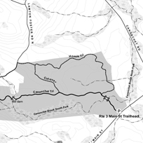
The Rte 3 Main St Trailhead serves both Hopkinton Land Trust and TNC Canonchet Preserves properties. Most trails are in the upland woods with good winter views to the wooded swamp that follows Canonchet Brook South Fork. A dam and mill operated whereCanonchet Trail crosses the South Fork via a stone bridge in the west. This western area is rugged with boulder upon boulder, glacial erratics and edge outcrops.
Walking past the stone walls, house and barn foundations, the old mill and extensive stone works at every turn along Canonchet Trail links you back centuries to those who came before. Canonchet Trail continues west and north to Stubtown Road, crossing other HLT and TNC Canonchet Preserves properties.
Click the links below to download:
Hoxsie Preserve at Canonchet Preserves – Black and White
Brushy Brook Expansion Trail
History: This area along the Wood River matches the documented criteria for a Native American occupation site (a village): 0-3% slope, well-draining soil, intersection of a smaller stream (Brushy Brook) with a larger navigable stream (Wood River), near both swamp and uplands. The Rhode Island Colony began selling off the Vacant Narragansett Lands which included Hope Valley in 1711, 35 years after King Phillip’s War. The first dam and waterpower mill site in Hope Valley dating from 1755 can be viewed downstream from the fishing platform. The trail follows the Right-of-Way of the Wood River Branch Railroad which served passengers and freight from Depot Square to the main line at Wood River Junction 8 miles away from 1880-1946.
- Area closed dusk (½ hour after sunset) to dawn (½ hour before sunrise)
- Dogs allowed on leash only; collect and remove dog waste
- Leave no trace; Please carry out trash and used fishing line
- Motorized vehicles
- Fires, camping and swimming.
- Dumping, littering, and trash disposal
- Removing, cutting, or damaging trees, shrubs, and vegetation
- Disturbing archaeological and sacred sites, stone walls, cellar foundations,dams, mill sites, grave sites, and stone constructions
- Moving or piling stones
- Metal detectors, digging or removing objects and minerals.
Brushy Brook Trail Map - Mechanic Street Access
Brushy Brook Trail Map - Depot Square Access
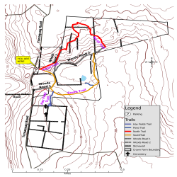
CROWN FARM
Trailhead located at 130 Tomaquag Road
• Area closed from dusk (1/2 hour after sunset) to dawn (1/2 hour before sunrise)
• Open for hiking, nature and cultural landscape appreciation
• Wear 200 sq.in of fluorescent orange during hunting season, generally from September through May
• Please respect surrounding property boundaries
• Dogs must be on leash
• Leave no trace; please carry out trash
• Motorized vehicles and bicycles
• Hunting
• Fires and camping
• Dumping, littering, and trash disposal
• Alcoholic beverages
• Removing, cutting or damaging trees, shrubs and vegetation
• Disturbing archaeological and sacred sites, stonewalls, cellar foundations, dams, millsites, gravesites and stone constructions
• Moving or piling up stones
• Metal detectors, digging or removing of objects and minerals
• Blocking gates
• Interference with farming activities
For emergencies ONLY Call 911
Report incidents to the Hopkinton Police (401)377-7750
Take Photos and get names if possible
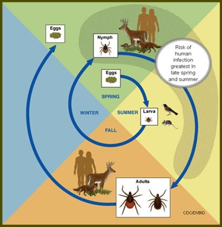
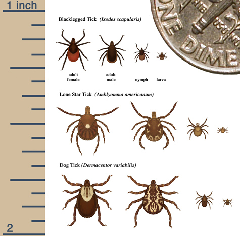
Tick bites can transmit Lyme Disease, Babesiosis, Ehrlichiosis, Powassan Disease, and Rocky Mountain Spotted Fever per RI Department of Health and The Centers for Disease Control and Prevention. Take precautions and check yourself for ticks often.
North Trail - 2C .50 miles Red
South Trail - 2D .52 miles Orange
Woods Road 1 - 1C .15 miles
Woods Road 2 - 2B .31 miles
Hay Fields Trail - 2C .12 miles
Pond/Overlook Trail - 1C .04 miles
Safety Guidelines
The Crown Farm Preserve is 124 acres. The northern hilly areas were pasture, now long grown back to forest. The hilltop to the south along Tomaquag Road remains hay fields. The wetland complex was a cranberry bog and was popular with local kids for ice skating. The larger of the two cemeteries is Native American.
In addition, the Friends of the Hopkinton Land Trust, Boy Scouts of America, Appalachian Mountain Club and other volunteer groups have previously established and continue to maintain the Town’s expanding trail system.
The following links will connect you to trail information for the individual organizations, whose lands are open for public passive recreation:
Boy Scouts of America - Camp Yawgoog